
Article · Pictou Island history
Fields Beside the Strait: Farming and Food on Pictou Island
Farming, fishing, household production and mainland supply in the Island’s agricultural history.
Fields Beside the Strait: Farming and Food on Pictou Island
Pictou Island’s agricultural history is easiest to misunderstand when farming and fishing are treated as separate worlds. The evidence points to households combining land, sea, household production and mainland supply. Farming was substantial, but the Island was never a sealed, completely self-sufficient community.
Heartz’s Pictou Advocate account of 16 April 1907 describes farming alongside fishing as ordinary Island work.
Agriculture formed part of permanent settlement early. An early statistical account reports 116 cultivated acres in 1827. By 1838, provincial census returns identified numerous Pictou Island household heads as farmers, placing agriculture alongside the Island’s other livelihoods.
Land and probate records bring individual farms into focus. The registered deed of 15 September 1863 records Hugh McDonald of Pictou Island, farmer, conveying the approximately fifty-acre eastern half of Lot 5 to Robert McDonald of Pictou Island, mariner, for $2. It names the late Peter Crerar, Deputy Land Surveyor, in its recital of a division plan dated 10 May 1830. The deed’s general buildings-and-improvements wording does not identify a particular building or establish Hugh and Robert’s kinship. The original plan and modern boundaries remain unresolved. Later wills document farms, stock, barns, implements and household support rights passing through the MacDonald, McDonald and Patterson families.
What a farm meant within a household
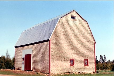
Individual wills give the agricultural totals a human scale. Hugh MacDonald’s 1887 will left a cow to Agnes McCallum. Donald McDonald’s 1896 arrangements reserved a cow, a heifer, a calf and six sheep for Helen, together with shared rights to a barn. These provisions show livestock and access to buildings being used to support a household after a death.
Alexander McDonald’s 1897 will dealt with stock and farming implements, while Malcolm Patterson’s will recorded farm division and a lifetime property interest. The documents connect farming with inheritance, housing and continuing support. They do not show that every Island household followed the same arrangements.
Fields, crops and livestock
The agricultural censuses show the scale of twentieth-century farming. In 1931, 36 occupiers reported 3,051 acres of occupied farm land and 880 acres of field crops. Hay dominated at 538 acres, alongside oats, potatoes, wheat, barley and roots. The tables also recorded horses, cattle, 418 sheep, 20 pigs and more than 1,200 hens and chickens. Seven acres belonged to the combined orchards-and-vineyards category, but no household or location can be assigned.
By 1941, farming remained substantial but several measures had declined: 33 operators occupied 2,878 acres, cultivated hay covered 492 acres, and livestock totals remained significant. The evidence describes contraction rather than sudden abandonment.
Food, supplies and shared labour
Local production did not remove dependence on mainland supplies. Oral histories remember grain and hay imports alongside gardens, livestock, food preservation, shared haying and shared butchering. These are attributed household experiences rather than evidence that every family worked in the same way. Ward MacCallum’s winter grocery crossing is told in the iceboat article.
Official occupation columns do not capture every form of household production. Blank entries cannot be converted into claims that women or children did no farm work, and the 1941 farm-worker category explicitly excluded housework.
Fields returning to woodland
The landscape changed gradually. Woodland within occupied farms rose from 1,403 acres in 1931 to 1,621 in 1941 while improved and crop acreage declined. Sherwood still described south-side open pasture in 1975, and later memories describe former fields returning to trees. The extent and timing of that landscape change have not been measured here.
Island households combined farming, fishing, transport, preservation, purchased supplies and shared labour in proportions that changed over time.
Sources for the household examples
Hugh McDonald to Robert McDonald, 15 September 1863, Pictou Registry Book 50, pp. 281–282; DGS 008621075, image 155. The original registered deed corrects the earlier reported folio 881 locator. Its plan reference is a later deed recital, not the original 1830 plan.
Hugh MacDonald will, HAGGIS 3101; Donald McDonald will, HAGGIS 3085; Alexander McDonald will, HAGGIS 2850; Malcolm Patterson will, HAGGIS 4200. Agricultural quantities come from the 1931 and 1941 Nova Scotia Census of Agriculture.
Sources and evidence notes
Heartz’s 1907 account is contemporary qualitative evidence, not a measure of acreage, farm numbers or crop totals. The 1838 occupation labels do not establish what each family grew or that farming was their only work. Census farm acreage and crop categories describe reported land use; they must not be converted into household-level locations without further evidence. The 1931 combined orchards-and-vineyards category does not identify a particular vineyard. Oral histories describe individual household experiences, and the timing and extent of later field regrowth remain unmeasured.
Trust authority and a resident lot purchase
The registered assignment of 23 March 1857 transferred John McGregor’s legal and equitable interests in Pictou Island to Charles Twining, both Halifax barristers, in trust. It recites debts and advances of £250 and upwards and authorizes sales and deeds, with proceeds applied after expenses to the advances and interest. This was a security and trust transaction, not a purchase of the whole Island for £250.
On 1 June 1858, Charles Twining conveyed eastern-end Lot 26 to John McFarlane, described as a Pictou Island yeoman. The deed describes about 100 acres on Peter Crerar’s 1830 plan and reserves the public road. Its £2 10s is the balance of consideration, not the total price. The registered deed is Book 45, page 248. It does not establish that the buyer was John D. McFarlane or prove a later 1908 estate transfer to Robert.
Pictou Registry Book 43, pp. 296–297: 1857 trust assignment; continuation; Book 45, p. 248: 1858 Lot 26 deed. The original 1830 plan, earliest resident purchase and modern boundaries remain unresolved.
Historical photographs